After you send in a layer update and we've republished your MXD you must configure the new layer on your ConnectGIS site. The steps below will walk you through the process of adding a new layer on ConnectGIS. If you experience any issues while adding your new layer please contact the GIS team for assistance.
-
Go to Manage Site in the top right hand corner of the site to access the Admin portal and log in.
-
To add a new layer to ConnectGIS, hover over Themes at the top of the page and then click on Edit Themes.
- Select the Theme you want to edit (typically main map or base map) by clicking on it.
-
Hover over Services at the top of the page and click Edit Services. Select a Service by clicking on it.
- Hover over Services at the top of the page and select Layers.
-
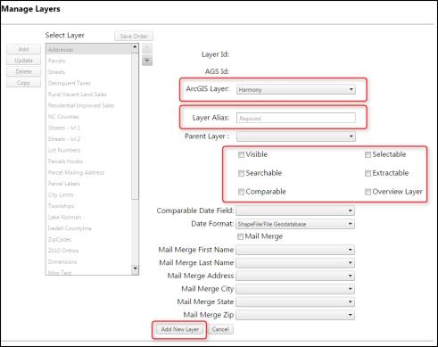
Now you can see all of the current layers on your map. To add a new layer click Add on the left side of the screen.
-
Use the drop down to select the layer (ex. WaterMain) you want to add to the map.
-
Fill in the Layer Alias (ex. Water Main).
-
Select if you'd like the layer to be: (You can select multiple options)
-
Visible (automatically on when you log into the site)
-
Selectable (able to use the identify tool with the layer)
-
Searchable (able to use search functions)
-
Extractable (enables others to download layer data)
-
Comparable (able to use comparable search)
-
Overview Layer (makes the layer appear in the overview search)
-
-
Click Add New Layer at the bottom of the page. (Do this for each new Layer.)
-
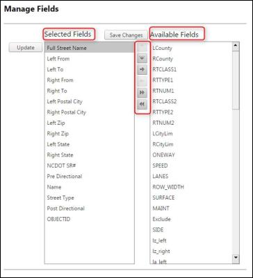
- You will then be sent back to the Manage Layer page. Make sure your new layer is highlighted and then hover over Services and select Fields.
-
On the Manage Fields page, move the fields from Available Fields to Selected Fields using the arrows between the two columns. Once all fields have been moved over click Save Changes above the columns.
-
(Optional) If you want a field to be searchable, select the field under the Selected Fields column and then click Update.
-
Check the Searchable box.
- You can also add Search Help Text (ex. Field: Owner Parcel Name, Search Help Text: John Smith) and Search Suggestion Length.
-
Click Update Field. Do this for each field you want to be searchable.
-
-
|

|
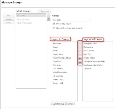
- Once you have added each new layer and fields hover over Themes and click on Groups.
- Select the Group you want to add your new layer(s) to and click Update.
In the Ungrouped Layers column select the layer you want to add to the group and click the arrows to move the layer to the Layers in Group Column. Once all layers have been added to the group click Update Group at the bottom of the screen.
-
The last step to adding a new layer to ConnectGIS is to update the User. Hover over the User tab and select Edit Users.
-
Select your user name under the Select User column and click Update on the left side of the screen.
-
Select your Project and click Edit Themes at the bottom of the page.
-
Select the Theme under Allowed Themes and click Edit Layers.
-
Move the layer(s) from Available Layers to Allowed Layers by clicking on the layer and using the arrow to move it to Allowed Layers.
-
Once all Layers have been moved over click Save Layers below the Allowed Layer column.
-
-
Now your new layer(s) should be visible when you view your map. To view your map go to the Map tab at the top of the page and select View Map.
New layers must also be added to your guest user. Once the layers are configured, please send an email to support so we can add the new layers to your guest login.